
Pilot Rock is another of the granite plutons found in the Pisgah Ranger District of Pisgah National Forest. Not as spectacular as it’s more famous cousin, Looking Glass Rock, Pilot still offers remarkable views of the Blue Ridge Parkway and national forest, including the Cradle of Forestry National Historical Site. It’s a short mile climb of almost 700 feet from the valley floor to the southern face of Pilot Rock. The forest changes along the way; from birch saplings to oak and maple, and the omnipresent laurels that embrace Western North Carolina. This hike occurred on Wednesday, October 24, 2012 from 11:30am to 1:00pm. My plan was to climb the Pilot Rock Trail to the pluton, then make a visit to Bradley Creek, farther down Forest Road 1206.
Hike Length: 2.2 miles Hike Duration: 1.5 hours Blaze: Orange
Hike Rating: Moderate Hike Configuration: Up and back
Elevation Gain: 690 feet
Trail Condition: Fair. Rocky, and leaf covered in Fall.
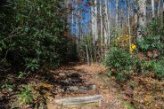
Starting Point: Pilot Rock Trailhead #321 on Yellow Gap Road.
Trail Traffic: I did not encounter anyone else on this hike.
How to Get There: From the Brevard, NC junction of Hwys 64/276 take US 276 into Pisgah National Forest 11 miles. Turn right on Forest Road 1206 (Yellow Gap Road), drive approximately 4 miles, trailhead located on left with parking on the right.
Are you looking for a short hike to get a great view of Pisgah National Forest from above? Well, Pilot Rock is your ticket to a pleasant and enjoyable forested hike that climbs nearly 700 feet in just one mile. From the rock there are unobstructed views of the Blue Ridge Parkway and the Cradle of Forestry National Historical Site, as well as a wide expanse of beautiful, lush, protected forest lands.
The trailhead for Pilot Rock Trail is one of many great hikes that begin on Forest Road 1206 otherwise known as Yellow Gap Road, less than a half mile beyond the Forest Discovery Center and Pink Beds off Scenic Highway 276. Once on the gravel forest road, it is four miles to the trailhead, located on the left side of the road. There is parking available for 3-4 cars.
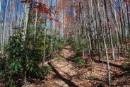
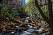
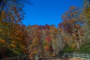
Take note of a confusing turn in the trail just a hundred feet up. The trail appears to go straight ahead, but instead bears to the right. The straight ahead trail goes to a campsite. So bear right, and you will immediately cross Bradley Creek on a log bridge. Once across the creek, the trail begins a steady climb through an amazing forest of thin and numerous birch saplings.
This is an enjoyable area no matter the season. In winter, when the trees are bare, you can see through the forest to the base of Pilot Rock. In late September look for the bright yellow leaves to signal the start of a brand new autumn, and in spring and summer the birch is alive with a vibrant, verdant showcase. The National Forest continues to recover from the logging of the early 20th century.
You will cross an old logging road (stay on the orange blazed trail straight ahead), and the trail begins to climb in earnest. Next comes the first of two series of switchbacks that make the ascent more moderate. Watch your step, especially in late autumn when the trail is covered with fallen leaves. There are roots and loose rocks hidden beneath those leaves that will easily twist an ankle.
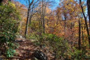
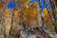
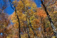
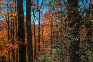
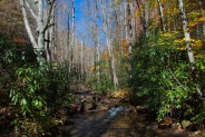
Once the trail straightens out again, it enters a boulder field and a change in the makeup of the forest. Look for oak here, and maple, poplar and of course mountain laurel. I was lucky to find this stretch still rocking the bright autumnal hues, so I paused for a break on the boulders and snapped off a few pictures.
Not long after clearing the boulder field you’ll hit the 2nd group of switchbacks, this one just a little bit tougher. If you start to breathe hard, fear not, you are almost to Pilot Rock. As the trail makes a sharp easterly turn, it will pop out of the forest with the granite of Pilot Rock to your right and just below.
You will notice immediately that the face of Pilot Rock is very steep. Hopefully, you have hiking shoes with good grip because you will need it as you inch your way down to take in the scenery. If this rock is even the slightest bit wet be very, very careful. If you slip and begin to slide downwards, you won’t stop for a very long way. If icy in winter, I would recommend that you not even set foot on the rock face. Just enjoy the view from the trail.
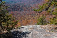
Again I was lucky, as on this bright sunny day Pilot Rock was completely dry and I was able to navigate its surface with ease. If you go down the face about 30-40 feet you’ll clear the trees completely and have a 180° view of the surrounding mountains. A light breeze helped dry the perspiration from my face as I took out a snack and the tripod.
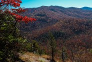
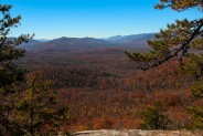
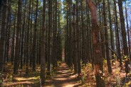
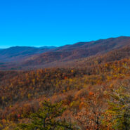
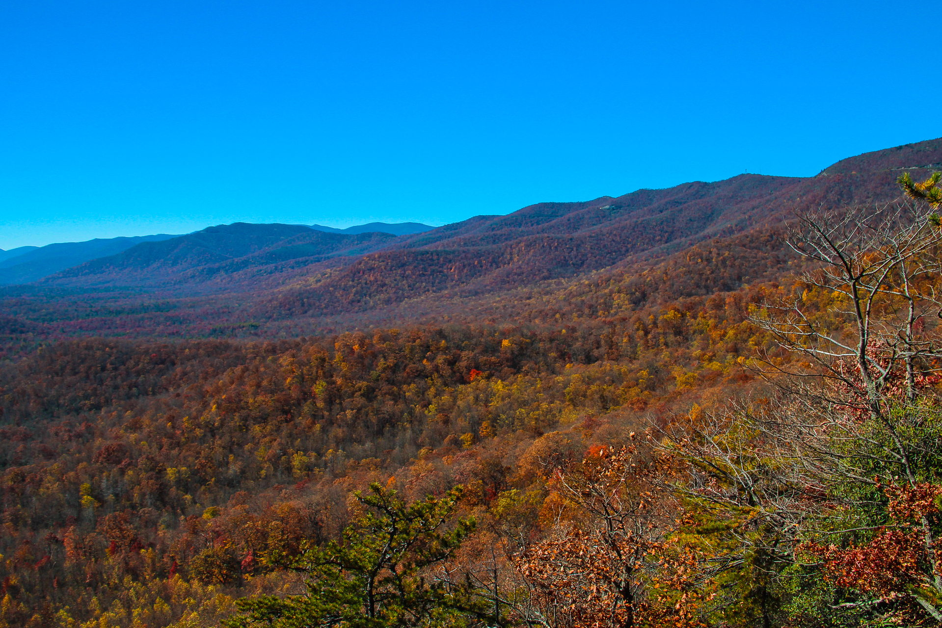
Straight ahead, to the south, is the Cradle of Forestry. It is nestled in a large valley that is filled with every color of tree imaginable (well, maybe not blue). You can barely make out the ribbon that is Yellow Gap Road slicing through the forest. There are pockets of pine and stands of spruce surrounded by the hardwood, remnants of the experimental forests that were planted in the heyday of the forestry school.
The westerly view is perhaps the most spectacular. That’s the photo at the top of this post. Click it for a larger image. You can follow the Blue Ridge Parkway as it winds its way from ridge to ridge nearly 5000 feet high. Starting from the northwest there is Fryingpan Mountain with its trademark fire and communications towers. Next is Beech Knob and then the junction where Hwy 276 meets the Parkway. Continuing southward, through Wagon Road Gap you can make out the 6000′ summits of the Black Balsam area far in the distance. You’ll then see the Parkway make a sweeping hairpin turn at Pounding Mill Overlook (the one I take care of as a Park Service volunteer), and continue its journey toward Great Smoky Mountains National Park.
The eastern view from Pilot Rock is the most difficult to see because of the angle, but you can make out Funneltop Mountain across the valley. The face of Pilot Rock continues around the mountain to the east so you can eventually see Slate Rock, but it’s a dangerous proposition. I vote for safe rather than sorry.
I stuck around for about 20 minutes taking pictures and enjoying the beautiful scenery and weather. There was not a cloud in the sky. The fall foliage was perhaps a week to ten days past peak color, but it was still a delight. It sure beats working.
When finished, I resumed Pilot Rock Trail for an additional tenth mile or so. It continues uphill for another two miles before eventually coming out at the parking area and trailhead for Mt. Pisgah. If you want to make a complete day hike of it, combining these two hikes would be a fantastic way to take in this section of Pisgah National Forest. But I wanted to get back to Yellow Gap Road and spend some time on Bradley Creek.
Because I was hiking at midday, on the way back down the sun had changed directions and was now casting a fabulous glow on the colorful trees in the boulder field. Bright orange and yellow were all the rage as I rustled my way through the thick bed of recently fallen leaves. There wouldn’t be any wildlife today. The swish and crackle beneath my feet made too much noise.
It’s about another three miles east on Yellow Gap Road to the trailhead for Slate Rock Creek. At that trailhead, Slate Rock Creek meets Bradley Creek in a picturesque deep forest setting that always lures me whenever I find myself near there. It is unbelievably green. I have been there in December and seen the rhododendron leaves still totally green. The hardwood trees were just barely showing color to indicate they were willing to shed their leaves. It’s amazing what water will do.
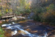
It was still fairly early in the afternoon, so I walked up the Slate Rock Creek Trail about a quarter mile just to enjoy the rushing sound of the stream and the solitude of the forest. I pulled up a rock on the creek bank and sat for awhile, splashing my face with the crisp, clean mountain water and giving thanks to those a century ago who had the forethought to protect this wonderful wild place for you and me and those who come next. I am so very fortunate to live where I do.
Eventually my mind returned to now and I headed back out Yellow Gap Road to Hwy 276. I stopped a few times alongside Looking Glass Creek to take some pictures and pulled into Sliding Rock just to see what it was all about. Even though I’ve lived here for half a dozen years, I’d never managed to check out Sliding Rock. It was closed for the season, of course, which meant I could explore the grounds and see what I’d been missing. I can see it being fun summer family water entertainment that for just $1 per person would be quite refreshing on a hot muggy day.
In summary, the Pilot Rock Trail is a moderately steep trail to a fantastic view of Pisgah National Forest. At an easy pace, you can make it to Pilot Rock in 30 minutes. Depending on how long you stay, you can be back in an hour ready to tackle one of the other trails on Yellow Gap Road. If you want to make a full day of it, Pilot Rock Trail continues up Slate Rock Ridge for another couple miles to the Blue Ridge Parkway where you can then hike to the summit of Mt. Pisgah if you desire.


The following are paid links. As an Amazon Associate I earn from qualifying purchases.
 I am Jeff Clark, founder of Internet Brothers, producer of this blog, and passionate about hiking. I live in Western NC near the Blue Ridge and Great Smoky Mountains. Pisgah and Nantahala National Forests are just out my door, so the content will focus on these areas, but let me know what you would like to see on the site.


Copyright © 2011-2023 Internet Brothers. All Rights Reserved. ISSN 2324-6057
Designed by Elegant Themes | Powered by Wordpress | Logo by Design Aspirations


Loved Pilot Rock. Went on November 12, a wet and cloudy day. Too wet to climb on Pilot Rock, but a great day to continue up above it to meet the Mtn-to-Sea Trail near Pisgah Mt, then back down. Great trail! Didn’t see a soul. The hike up to Pilot Rock is so short, that adding the upper part to Mtn-to-Sea Trail is a great addition. Trail well-maintained.