
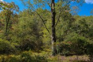
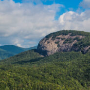
The always popular Cat Gap Loop Trail is a jumping off point for many great hikes within the Davidson River area of Pisgah National Forest. Included among them is the picturesque John Rock, one of the area’s plutons that stand over the recreation area. With views of the Fish Hatchery, Looking Glass Rock, Pilot Mountain and the ridges that run to Graveyard Fields, John Rock is a great spot for scenic vistas on your way around the Cat Gap Loop. This is a complete hike. In addition to the great views on John Rock, the trail follows two different creeks and meanders through both hardwood and evergreen forests. Be prepared for some climbing. You will gain more than a thousand feet. Good exercise, beautiful forest, cool mountain streams and long-distance views — what more could you ask for? This hike occurred on Thursday, September 20, 2012 from 9:15am to 12:40pm. Our plan was to start at the fish hatchery along Davidson River looping the Cat Gap Trail clockwise. We would take the John Rock Trail at mid loop.
Hike Length: 6.8 miles Hike Duration: 3.25 hours Blaze: Orange, yellow
Hike Rating: Moderate, some strenuous Hike Configuration: Loop, with cutout
Elevation Gain: 1,107 feet Elevation Change: 970 feet
Trail Condition: Mostly very good. Some creek crossings and rooty areas.
Starting Point: East end of the parking area at the fish hatchery along FR 475.
Trail Traffic: We encountered two other hikers on the trail, from The Netherlands.
How to Get There: From Brevard, NC get onto Scenic Hwy 276 west into Pisgah National Forest. Go 5.2 miles, then turn left onto Forest Road 475. After a mile, turn left into the state fish hatchery. The trailhead is at the east end of the parking area.
If you wish to do this hike clockwise, then start at the east end of the fish hatchery parking lot. Counterclockwise? That trailhead is next to the Conservation Education Center. Either way, you will be coming out vice versa at the end.
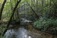
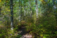
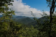
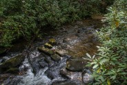
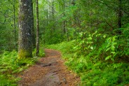
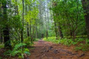
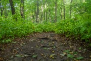
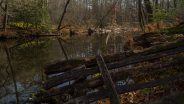
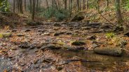
Our three man crew chose to make like a clock because it is the shortest route to John Rock. The orange blazed Cat Gap Trail starts where John Rock Branch meets Davidson River. Not long after the trailhead, you will cross the creek for the first time, one of several along the way. This first one has a bridge, but don’t expect that luxury later on. Because Cat Gap Loop is so popular, it has become a fairly wide track, well-maintained except for some exposed roots and occasional muddy areas.
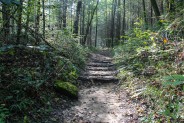
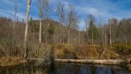
The trail wanders through Horse Cove, a section of Pisgah National Forest known for marshy wetlands. Occasional spur trails are available to explore the wetlands. Just watch where you step. It can get squishy. The main trail again crosses John Rock Branch about a half mile in, this time over rocks in the stream. Be careful as you cross. The wet rocks can be slick. From here, the trail begins ascending the east side of John Rock Ridge and soon crosses Forest Road 475C. Just a few hundred yards more and you will reach the junction with John Rock Trail.
It’s a right turn on a yellow-blazed trail that begins a steep climb almost immediately. You will climb 470 feet in the next half mile, so test your lungs to make sure you can breathe deeply. For some reason my hiking partners felt the need to challenge each other, so they took off on a jog up the trail. Call me old fashioned, but I hike to enjoy the scenery and the wilderness, so I lagged behind and took plenty of pictures of the beautiful green forest. The higher I got though, the more the fall coloring was just beginning to make its annual appearance.
I remembered from previous visits to John Rock that a spur trail takes off to the right from the main trail and pops out on the lower end of John Rock. I looked for that as I approached the crest of the ridge and found what I thought was the proper spur. 100 feet deep into the laurels I discovered a dead end. I was stymied by thick rhododendron and mountain laurel and could go no further. False trail #1.
So, back to the main trail I went and further up the ridge to false trail #2. Again, I headed westerly on a spur trail but came to another dead end. I spent the next 20 minutes going back and forth on the main John Rock Trail looking for the correct spur to go to the rock. My hiking companions were nowhere to be seen, so apparently they found John Rock alright. Eventually, one of them came back looking for me and I discovered I just didn’t go quite far enough. The spur trail that I was looking for was just another 50 feet beyond the 2nd false trail. Darn it!
I shared this story of my frustration to make a couple points about experience gained in hiking. First, when hiking with companions it is best to stay together. If everyone has their own agenda, it’s too easy to get separated and ultimately lost. Stick together. A good rule of thumb is to proceed at the pace of the slowest hiker. Second, a warning about the John Rock Trail. Since I last visited there are a number of false trails created by those who thought they were taking a shortcut to the rock. In general, be aware that this can happen anytime, anywhere. False trails are no good, so don’t make them. You never know when a Meanderthal like me may try your false trail months later.
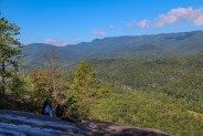
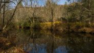
After explaining the embarrassment of getting lost in the woods to my friend, we joined the third member of our group on the south end of John Rock. Most of the rock was covered with a thin layer of water, drainage from rains earlier in the week. This made for a dicey proposition navigating the large granite pluton. The face is pretty steep and you definitely don’t want to go over the edge. It’s about a 600 foot drop to the base near the fish hatchery below. Also know that this wetness will be ice in the winter. Be very careful.
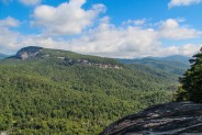
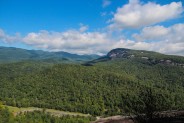
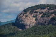
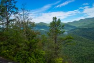
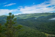
The good news is that it is worth every step of the climb, every huff and puff, even getting temporarily lost. This is one of the most picturesque spots in the Pisgah Ranger District of Pisgah National Forest. Directly in front of you to the north is Looking Glass Rock, the mammoth pluton that gives this region its character. You can see the entire length of the western face of Looking Glass. If you have binoculars or a zoom lens you may be able to locate hikers on either the lower or upper overlooks clear across the valley.
Directly below is the fish hatchery and the Education Center where you parked. There are almost always crows and/or ravens, buzzards or even peregrine falcons hovering over the hatchery. Listen closely and you might hear the tell-tale “kronk” of the ravens.
To the west you can follow the path of the Art Loeb Trail as it climbs the ridge to Pilot Mountain. Continue looking in a northwesterly direction and observe the ridge to the Blue Ridge Parkway. Beyond the Parkway is the high country, the Graveyard Fields and Black Balsam area. The majesty of the mountain balds makes a remarkable view.
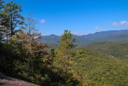
Turning around and looking to the east you will see the southern end of Looking Glass with Black Mountain behind. It’s another long distance view of the Blue Ridge Mountains in the background and the Davidson River valley below. It was a delightful day for us with blue sky and puffy whites and a freshness in the air. We took plenty of time to enjoy the scene and grab some nourishment before continuing on our way.
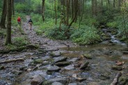
Replenishing your energy is a good idea because the ensuing half hour is the hardest part of this hike. Exit John Rock on the south end, up and into the forest. Over the next half mile you will gain 200 feet, then lose 100, gain 100, then lose 75. Finally, the third climb will take you to the summit of John Rock Ridge and a wonderful view off to the east. From the summit it is then a steep 350 foot descent over the next quarter mile to a major trail junction. We passed a Dutch couple coming up as we were going down. They were in awe of the mountainous beauty of Western North Carolina.
At the junction you have a number of options. You can take the Cat Gap Trail north back to your car. You can take the Cat Gap Trail south up and over Cat Gap to a meeting with the Art Loeb Trail. From there, you again have several options if you wish to take a long hike. Or, you can do what we did on this day, and take the Cat Gap Bypass westward. The good news about the bypass is that it is flat, unlike the southern route of the Cat Gap Loop that climbs back up all of the elevation you just descended coming down off John Rock Ridge.
The Cat Gap Bypass is an excellent trail. It’s in tip-top condition, very smooth and wide. It wanders below a ridge through thick, colorful forest filled with fresh scents and feathered sounds. You will enjoy this trail for about a half mile until it rejoins the Cat Gap Loop coming back down from the ridge above.
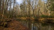
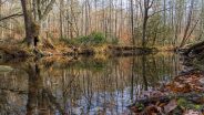
The trail soon picks up Cedar Rock Creek and crosses it a couple times. One crossing is by hopping stones, another via log foot bridge. Look for some nice small waterfalls along the creek. You will have to drop down off the trail 20-30 feet to get a closeup view, but well worth it. For the campers out there, you will find plenty of sites along the creek on this western side of Cat Gap Loop.
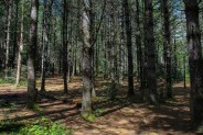
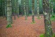
To the west of the trail is an area known as Picklesimer Fields, more lush green forest with soft cushy ground cover than what I would describe as fields or meadows. The look of the forest on this side of the loop is completely different, and it becomes even more so after passing Picklesimer. Suddenly you enter a deep and dark white pine forest that is as stunning in its appearance as it is refreshing in its aromatic splendor. The forest floor is carpeted with a thick covering of pine needles that make the trek through the pines all the more pleasant. This area is always a nice surprise.
Soon after the pine forest, Cat Gap Loop joins the Butter Gap Trail for the final return to the fish hatchery. As you traverse the last 3/4 mile, you will see a green chain link fence on the left that is boundary for an experimental forest. It’s a bit of a roller coaster through the area, but the trail never gains or loses more than 20 feet at a time. Do you perhaps smell fish? Well, that means you’re getting close to the hatchery and the end of the loop, just under seven miles of hiking since you began.
John Rock is one of those must hikes in Pisgah National Forest. If you’re a local, you will find yourself doing this hike time after time simply for the sheer beauty presented on top of the rock. If you are an out-of-towner, I also recommend this hike as a good way of familiarizing yourself with the Pisgah Ranger District. The Cat Gap Loop presents so many options for great hiking with its many, many junctions that go far and wide into the forest. Just make sure to stop and enjoy the vista found on John Rock.

Update September 3, 2014: Time for another trip to John Rock. The scenery was as spectacular as always. I think it’s worth noting, though, that the Cat Gap Trail is experiencing a lot of erosion. Each of the last two summers have been especially wet, and the hilly sections of the trail are washing away with the rain. Otherwise, it was a thoroughly enjoyable hike, as always. Hope you like the new photos.


Update November 25, 2016: I haven’t shown you yet what Cat Gap Trail and the Davidson River look like when the leaves are down. Drought conditions this Fall have slowed the creeks and streams to little more than a trickle, but it is still always great to #optoutside.


The following are paid links. As an Amazon Associate I earn from qualifying purchases.
 I am Jeff Clark, founder of Internet Brothers, producer of this blog, and passionate about hiking. I live in Western NC near the Blue Ridge and Great Smoky Mountains. Pisgah and Nantahala National Forests are just out my door, so the content will focus on these areas, but let me know what you would like to see on the site.


Copyright © 2011-2023 Internet Brothers. All Rights Reserved. ISSN 2324-6057
Designed by Elegant Themes | Powered by Wordpress | Logo by Design Aspirations


Took this hike today. I usually check your blog before I head out on any trails in WNC and greatly appreciate your insight into these wonderful hikes. This was beautiful! I went counter clockwise. The rain has been coming down for days, so there were a few wet spots. The variety in the forest is amazing, and the pine forest was a special surprise. The waterfalls just a short way off the trails are well worth checking out. The trails are well marked (a very nice change from Shining Rock – all though if you have a map and are observant it is no problem!) and oh. my. goodness! What a breathtaking view when you make it out onto John’s rock. W O W!
Definitely one of my favorite hikes so far in WNC. Easily manageable in a day, but long enough and a few elevation changes to feel like a good hike.
I saw two groups of kids with guides and some other folks, so don’t second guess yourself if you’re interested in this trail – it is gorgeous and perfectly manageable.
Cheers!
Thanks Jeff!
Glad you enjoyed it Patrick. The view of Looking Glass Rock from John Rock is probably the best in Pisgah Forest.
Jeff, I want to return to the Pisgah National Forest and hike the CatGap Trail to John Rock in memory of my husband, John, who recently passed. He and I hiked in the Forest a couple of years ago, fell in love with the area and wanted to return. Are there individuals in the area who offer guided hikes to John Rock? Thanks for your reply.
Terri, I am sorry for your loss.
I don’t know the answer to your question, but here is the phone number for the Pisgah Ranger District (828-877-3265). Likely a ranger there will know how to help you.
Thank you.