
DuPont State Forest, in western North Carolina between Hendersonville and Brevard, was sold to the state by DuPont Corporation under favorable donation and conservation terms in 1996. Within its boundary are more than 10,000 forested acres and 80 miles of hiking and biking trails. Elevation ranges from 2300′ at Hooker Falls on the Little River to 3600′ on Stone Mountain. The state forest lies on an upland plateau of the Little River Valley with moderate hills and mountains that are topped with large granite domes and slabs. Cedar Rock, loved by hikers and mountain bikers alike, is one of those large domes covering hundreds of acres. This hike occurred on Thursday, December 15, 2011 from 11:50am to 1:30pm. The plan was to climb Cedar Rock by taking the Corn Mill Shoals Trail to the Little River Trail, then on to the Cedar Rock Trail to the summit, and back down on the Big Rock Trail.
Hike Length: 3.15 miles Hike Duration: 1.5 hours + lunch
Hike Rating: Easy Blaze: No blaze, cairns used on the granite
Elevation Gain: 455 feet Hike Configuration: Loop, up then back down
Trail Condition: Excellent, watch for ice on the granite in winter.
Starting Point: Trailhead is at the Corn Mill Shoals parking on Cascade Lake Road.
Trail Traffic: We encountered no other hikers, but we did meet 4 mountain bikers.
How to Get There: DuPont State Forest can be accessed from Hendersonville via Kanuga/Crab Creek Rd., from Asheville/Brevard via US64 and Little River Rd., or from Greenville, SC via Cedar Mountain and Cascade Lake Rd. Look for printed trail maps at public parking areas.
This short scenic hike is ideal for young and old, hiking beginners and veterans alike. It’s short enough that it won’t tire the oldsters or out-of-shape couch types, yet challenging and adventurous enough to keep seasoned hikers entertained. If mountain biking is your thing, then you will love these trails too. The weather has been unseasonably mild in the Carolinas this December, so my companion and I got a late morning start so we could enjoy the forecasted sunshine and mid-sixties temp. Someone just forgot to tell Mother Nature as it was misting, grey and windy when we put our boots down on Corn Mill Shoals Trail.
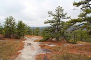
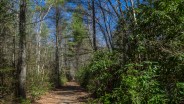
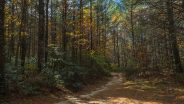
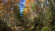
The trailhead is across Cascade Lake Rd. from the parking area. Look both ways before crossing. The first 3/4 mile is a flat stroll through a conifer forest comprised primarily of hemlock and white pine. Trails and junctions within DuPont State Forest are well signed, even though there aren’t any colored blaze marks. If you have one of the handy state forest trail maps available at the parking areas or here, it is quite easy to find your way. The first junction we came to was for the Burnt Mountain Trail, but that was a destination for another day. We continued on Corn Mill Shoals just a bit further to the fork with Little River Trail. We took that to the left.
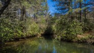
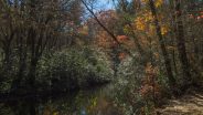
Little River isn’t really much of a river in this section of the forest, more like a creek, but it does roar over major waterfalls in other areas within the boundary. Here, it is enough to entice the rhododendron to plant themselves and offer a channel for the trail to follow. While a beautiful scene in December, be sure to check out this area some time in June too so you can enjoy the flowering rhodies. I make little mental notes to myself throughout the year of places filled with thickets of rhododendron so I can return for the seasonal efflorescence. Western North Carolina is so rich with rhododendron that my list is beginning to overflow from my ears.
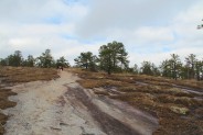
Another flat 3/4 mile and we reached the junction with the Cedar Rock Trail. You can continue an additional half mile on the Little River Trail to make a larger loop with the Cedar Rock Trail, but we were anxious to get to the top just in case that threatening weather decided to take a turn for the worse. Cedar Rock Trail climbs 450 feet in a little more that half a mile. That may seem somewhat strenuous, but it really isn’t too bad. It’s all over hard, even granite without any rock scrambling or switchbacks.
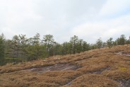
I really like this section of the trail. This was my second visit to Cedar Rock Mountain, and upon glimpsing the scene I immediately remembered the special appeal. The granite is covered with an odd but beautiful moss/lichen vegetation that fills my addled brain with questions. How does it grow on the rock? How does it thrive year round, remaining green even in winter? The forest management folks ask that we not walk on this fragile, sensitive ecosystem so that it will thrive and be available for future generations to enjoy, just as I do.
 Another great thing about the Cedar Rock Trail is the granite itself. I’m reminded why kitchen counter tops can be so colorful. Seams of mauve and taupe, yellow-green and grey run through the stone. Combine that with the streaks made by rain runoff through the vegetation and you’ll pique an interior decorator’s imagination. I tend to slow down climbing this trail
 — not so much because it is uphill — but because I like to look at the ground I walk on.
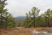
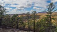
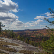
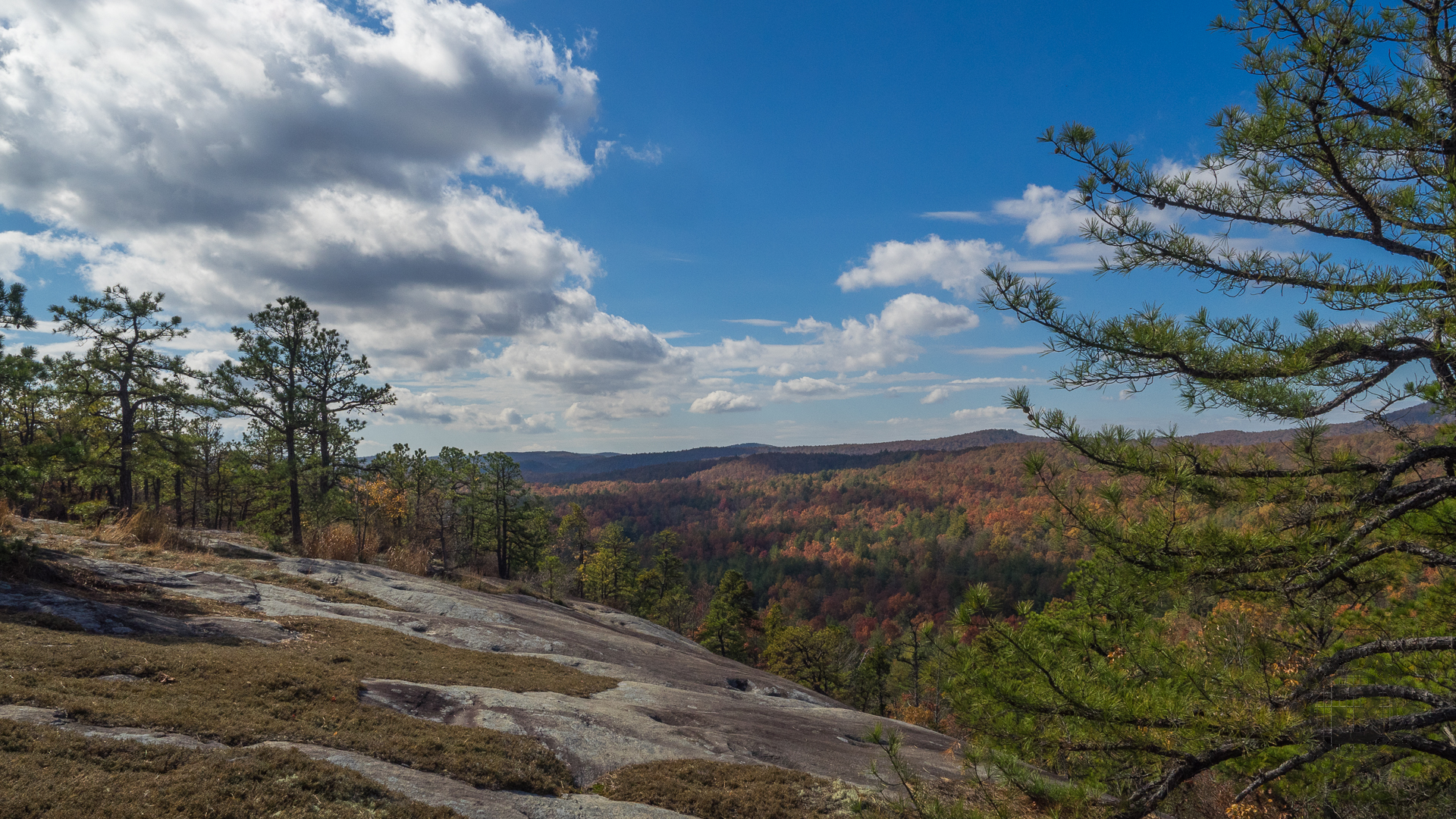
Don’t focus entirely on your feet though, because there is plenty to see to either side. To the right, or east, is a view of Joanna Mountain nearby and Grassy Mountain a little further in the distance. In the basin below is Lake Julia, but I haven’t been able to make it out with my old Meanderthal eyes. Perhaps you can. The westerly view is of what will be the descent trail, Big Rock. Behind are the mountains of the Blue Ridge Escarpment that shape the border between North and South Carolina.
At the summit of Cedar Rock is the junction with Big Rock Trail, and with the other end of the Cedar Rock Trail that comprises the larger loop I mentioned before. The top is quite flat, and large. The trail winds in and around the moss/lichen and the short, gnarly pine that manages to exist despite raging winter weather. The wind picked up. I started to leave my outer layer in the car when we began. It’s good to make myself remember that I can always take layers off, but I can’t put on what I don’t have with me. The north side of the Cedar Rock summit is a dome that has an inviting view of the Pisgah Ridge far in the distance to the north. A great spot for lunch.
We found a spot nestled up against a wind-break of pine bushes and told each other how we’ve frequented some of the best lunch spots the region has to offer. 4-star dining you say? I’ll take a turkey sandwich, a Henderson County apple, and a few pretzels on top of a mountain in the Blue Ridge any day.
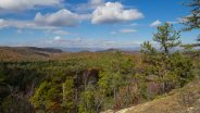
 Following lunch, I pulled out the monopod to take a few long distance photos of the high country in the distance, including the one at the top of this post. As we were gathering up our gear to head back down, we encountered a parade of mountain bikers
 — first one, then another, and finally a third — all solo riders just minutes apart. We paused to chat about mostly nothing except how fortunate we were to have this golden opportunity… as long as the rain held off.
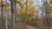
And so it did. We made it down the Big Rock Trail and back to the car without a drop. The first half of Big Rock is very similar to the Cedar Rock Trail with lots of the moss/lichen mix over a granite surface. About half way down it begins to change to more of a dirt surface and rhododendron lined pathway. It seemed like the end came too soon.
Since the day was still young, my friend suggested a way back home that he knew of that followed a dirt road over Pinnacle Mountain to Flat Rock, NC. I said let’s go. We took Cascade Lakes Road to Reasonover Road around the southern end of DuPont State Forest and past Reasonover Lake. There the road forked to Green River on the right and Pinnacle Mountain on the left.
It was about three miles of curvy, windy backcountry road that went from the vulgar to the sublime. After about a mile, we encountered a clear cut logging operation on the southeast side of the road. Totally ugly with no hint of remorse… we hoped they simply weren’t finished yet and would be back to replant and revitalize. Without remediation this side of the mountain will be prone to erosion and a blight on an otherwise gorgeous area.
But, after we crossed Pinnacle Mountain we entered horse country. Farm after farm of bucolic pastures with split rail fences, rolling hills, and hay shelters. There were horses all over. After the farms came the mountain subdivisions of the uber-rich with pavilions and amphitheaters overlooking Flat Rock and Hendersonville below.
If you’re looking for short hikes to stretch your legs, you can’t go wrong at Dupont State Forest. There are waterfall trails, forest trails, lakes and even a few small mountains to climb. I like to save DuPont trails for winter, because the elevation is 3000 feet lower than the surrounding high country, and there is less likelihood of encountering snow and ice.


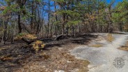
Updated March 29, 2016: Made another visit to this delightful section of DuPont State Forest. The understory alongside the Cedar Rock Trail was showing some scarring from recent prescribed burning, but that will be rejuvenated within a matter of months. Otherwise everything looked great on all the trails. Hope you enjoy the new photos below:


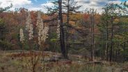
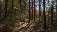
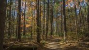
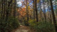
Updated November 2, 2017: It seemed like a Fall visit to Cedar Rock was in order. The oaks and maples come alive in late October to early November. The unseasonably warm weather has continued and made for short sleeve hiking weather the first week of November. Let’s hope this doesn’t mean another bad fire season in 2017. Enjoy the pictures!


The following are paid links. As an Amazon Associate I earn from qualifying purchases.
 I am Jeff Clark, founder of Internet Brothers, producer of this blog, and passionate about hiking. I live in Western NC near the Blue Ridge and Great Smoky Mountains. Pisgah and Nantahala National Forests are just out my door, so the content will focus on these areas, but let me know what you would like to see on the site.


Copyright © 2011-2023 Internet Brothers. All Rights Reserved. ISSN 2324-6057
Designed by Elegant Themes | Powered by Wordpress | Logo by Design Aspirations
I’ve never heard of this loop hike, Jeff. I look forward to trying it out in the spring as I’ve been wanting to do some hikes closer to the Asheville area. I’ve also heard that Hickory Nut Gorge offers neat hiking terrain. Have you been down there?
Hi Lori. Yes, I’ve been a couple places in the Hickory Nut Gorge. See the trail reports for Florence Nature Preserve and for Rumbling Bald. The nature preserve is kinda small, but a beautiful forest and Rumbling Bald is a hard climb, but worth it for the scenery up top. Hope you enjoy the new year!