
The Middle Prong Wilderness is west of North Carolina Hwy. 215 and north of the Blue Ridge Parkway. It is named after the Middle Prong of the Little Pigeon River that runs through the heart of the wilderness. This is remote territory in the high country near 6000 feet. Prepare yourself for heavy breathing — from exertion, and from natural beauty. Buckeye Gap Trail takes you to Middle Prong, then Haywood Gap Trail follows the river back up the drainage. This hike occurred on November 5, 2010 beginning at 8:00AM and ending about 2:00PM. Our goal on this day was to hike Buckeye Gap Trail to the bottom of Buckeye Gap where the trail intersects with Haywood Gap Trail for the climb back to the origin. The trailhead is at 5400 feet elevation and we were treated to the first early snowfall of the season. The dusting of snow made for a beautiful hike.
Hike Length: 9.7 miles Hike Duration: 6 hours
Hike Rating: Difficult Blaze: No blaze in wilderness area
Elevation Gain: 1,960 feet Hike Configuration: Loop
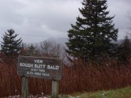
Trail Condition: Wilderness Starting Point: Rough Butt Bald Overlook
Trail Traffic: We saw one other hiker and his dog on this trail the entire duration.
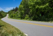
How to Get There: From Brevard, NC take Hwy. 276 approximately 10 miles to where it meets the Blue Ridge Parkway at milepost 412. Turn south and travel 13.4 miles to the Rough Butt Bald Overlook at milepost 425.4 on the parkway. The trailhead for the Mountains to the Sea Trail is across the parkway from the overlook.
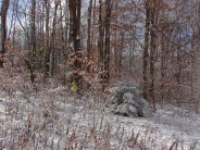
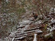
We got an early start on this hike because we knew it would be a long one. What we didn’t know was it had snowed overnight at elevations above 3500 feet. There sure wasn’t any snow on the ground at home. The 13.5 mile drive on the Blue Ridge Parkway to the trailhead kept getting snowier the higher we climbed. As we were parking at the Rough Butt Bald Overlook, a parkway maintenance worker pulled up in his pickup truck. He warned that the National Park Service may be coming along to close the Parkway at any time. The good news was Hwy. 215 was between us and the gate. So even if they closed the parkway, we could still exit on 215 when we finished our hike. Another prime example of Meanderthal thinking. I changed from low top to high top hiking boots because of the snow, and off the three of us went.
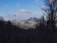
This hike begins with a stretch on the Mountains to the Sea Trail. The trailhead is located on the opposite side of the parkway road from the overlook. It is reasonably well marked. Along the MtS Trail we had 6110′ Mount Hardy to our right and the Buckeye Creek drainage to our left. When we rounded one particular bend in the trail, there was a nice look back toward the parkway at the snow covered forest in the distance. After 1.4 miles we reached Buckeye Creek and then the intersection with Buckeye Gap Trail. The next 1.9 miles is a comfortable, level stretch through a mostly hardwood forest. The trail itself is in very good condition. Fork Ridge is above on the right. With the overnight snow, it was very pleasant.
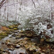
 From this point on, things changed, dramatically. The Buckeye Gap Trail makes a sharp left turn along Grassy Ridge Branch to begin its descent into the Middle Prong drainage. Unfortunately, we missed it, and apparently so had hundreds of people before us. There was clearly a trail straight ahead, but after about 300 yards, it simply vanished. Many people realized the same thing at about the same time; this is a false trail. So we backtracked, and sure enough, there was the turn to head steeply down… and suddenly it was slick. As long as we had been on level trail, the snow had not been a problem. The trail went down 1,800 feet in the next 1.2 miles. There were freshly fallen leaves under the 1/2 inch of snow adding to the slippage. I went down on my butt three different times. Nothing bruised but my ego. Finally, we reached the intersection with Haywood Gap Trail which comes up from the Sunburst camping area along with the Middle Prong of the Little Pigeon River.
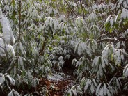
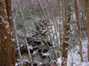
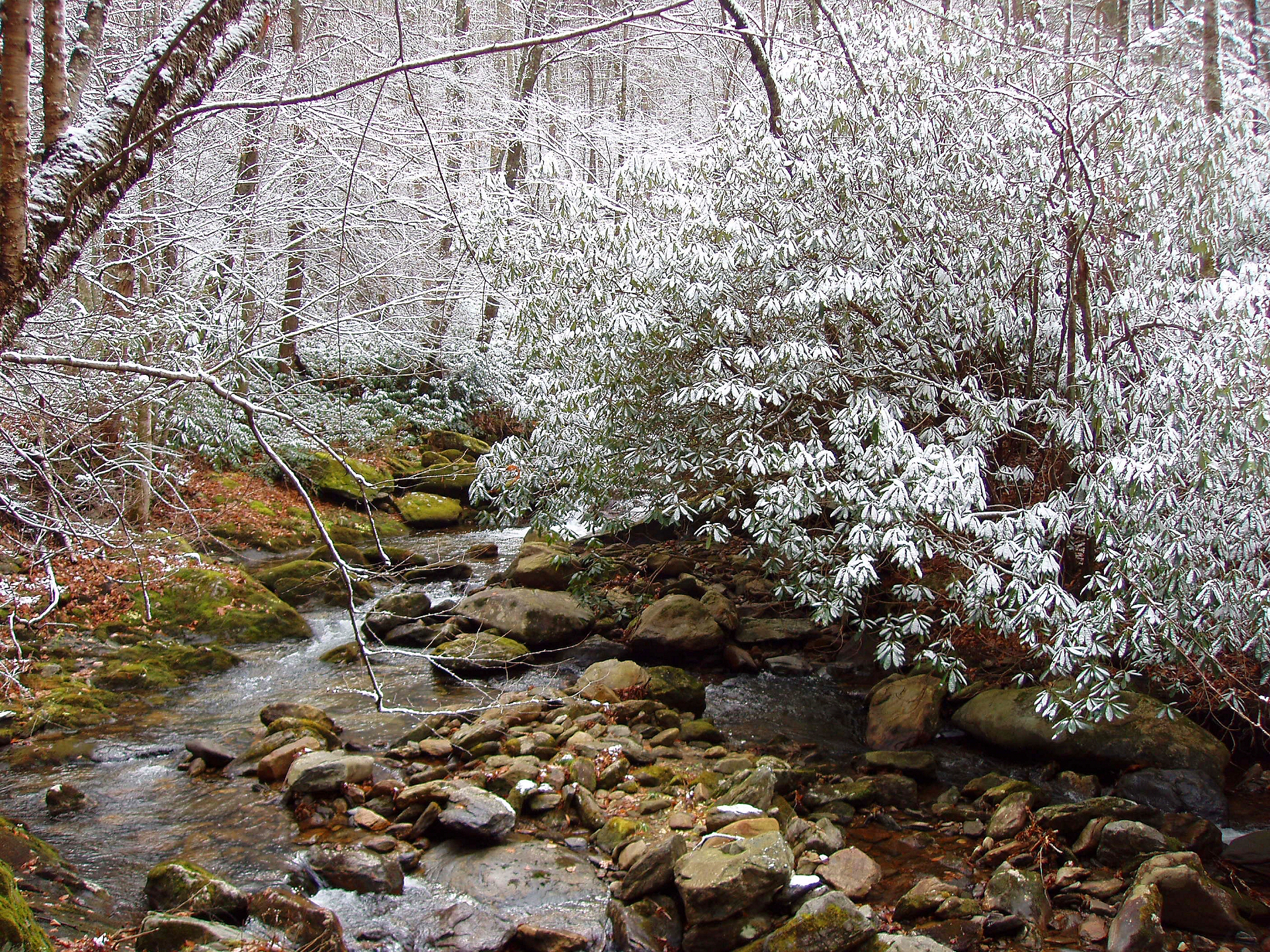
And it was stunning. The picture at the top of this report was taken of the snow dusting the rhododendron along the bank of the stream. This was a great time to have our lunch and enjoy the scenery. But just as we had descended 1,800 feet to get to the junction, we now had to climb that same distance up Haywood Gap. The trail followed the river for about a mile and the rhododendron was plentiful. It always grows very well in this region next to a steady water supply. There is plenty of water, and plenty of rhododendron. The trail passed through several snow-covered rhodo canopies that were breathtaking.
 The next two miles is a hump, all uphill. We passed Beartrap Knob on our right, and we paused for breath. We crossed the other end of Buckeye Creek cascading down to meet the Middle Prong, and we paused to whine about our burning legs. Don’t get me wrong, I love to hike, and I love the exercise, but y’know steep is steep. It hurts! It’s a long two miles.
Eventually the trail reaches Haywood Gap, and meets up with the Mountains to the Sea Trail to return to Rough Butt Bald Overlook. Also, the parkway is only another 100 yards ahead. We opted to finish the hike on the parkway figuring if it was closed there wouldn’t be any cars. Sure enough, there weren’t. The last .8 mile we walked the silent, peaceful parkway.
As we drove back north on the parkway, when we reached Hwy. 215, just as the maintenance worker had predicted in the morning, they had closed the parkway. So we could not get back to Hwy. 276 to return home. Instead we took 215 off the mountain and then Hwy. 64 to Brevard. It was a little bit longer, but it is always a beautiful drive. The snow made this hike. It was fabulous.


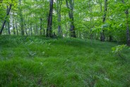
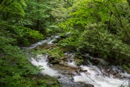
We decided to go back for a seasonal update on this loop through Middle Prong Wilderness. While our first trip had given us a surprise covering of snow, this hike followed a week of heavy rain in Western North Carolina. The creeks and river, and the tall grasses let us know they had been drinking in all the moisture.
In November the leaves were off the trees and we could see through the forest. In June the woods are a luscious, flourishing fresh promise. It was like a rainforest with large fungus growing on the trunks, and fields of verdant grass lining the trail beneath the overhanging canopy of poplar, beech and birch. The terrain is rugged and remote, a true wilderness.
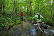
The grass made the legs and shoes very wet from the rain and early morning dew, and we found out right away from the first creek crossing that this was going to be an entirely different water day. Even the seeps were running deep and fast off the drainage from Mt. Hardy.
Nowhere was that more evident than the one crossing of Middle Prong River itself. We were looking at a 15 foot wide, two feet deep torrent of whitewater. We checked up and down river for an easier egress, but the bank was lined with coarse rhododendron thicket as far as we could see. Well, if you’re going to be dumb, you better be tough.
We shed our boots and socks, tied the laces together and wrapped them around our necks, and took the plunge. The frigid cascade of spring runoff was an assault on our senses, and our sensibilities. It was fist bumps all around though as the three of us remained standing throughout. The air was heavy with relief. Put another wilderness adventure notch on the Meanderthals belt.
There were still difficult crossings of Buckeye Creek and Possum Branch yet to come, but as you can see, we lived to tell about it. That’s the lasting impression I will leave you with of Middle Prong Wilderness in the spring. Very, very demanding and dangerous water crossings. The spring green of the forest is very beautiful, and enticing, but be careful around the water. Enjoy the new photos.


The following are paid links. As an Amazon Associate I earn from qualifying purchases.
 I am Jeff Clark, founder of Internet Brothers, producer of this blog, and passionate about hiking. I live in Western NC near the Blue Ridge and Great Smoky Mountains. Pisgah and Nantahala National Forests are just out my door, so the content will focus on these areas, but let me know what you would like to see on the site.


Copyright © 2011-2023 Internet Brothers. All Rights Reserved. ISSN 2324-6057
Designed by Elegant Themes | Powered by Wordpress | Logo by Design Aspirations
A fellow adventurer who explored this trail and was kind enough to write via the contact form reported that Conservancy volunteers have done some work on the left turn on Buckeye Gap Trail to make it more obvious. Hooray for trail maintenance volunteers!
Did this hike the Saturday before Christmas. It wasn’t quite as icy as your first visit but boy was that water cold. And they closed the parkway on us, too!
Thanks so much for all your detailed notes and for your photos. Your blog has become a go-to resource for me when finding detailed info about hikes.
Thank you for the kind words.
Thanks so much for the kind words.